
Topographic Survey vs. Boundary Survey: Key Differences Explained
A topographic survey maps the physical features of a piece of land, such as hills, slopes, trees, and drainage patterns. A boundary survey maps the legal edges of a property. Both are performed by licensed land surveyors, but they serve very different purposes and are used at different stages of owning or developing land.
What Is a Topographic Survey?
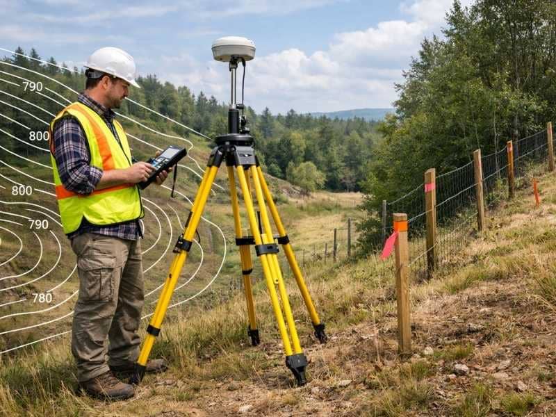
A topographic survey measures and records the natural and man-made features on a piece of land. It shows changes in elevation, the location of structures, trees, water bodies, and other physical details. Engineers and architects use topographic surveys to plan construction projects before any building begins.
A topographic survey gives a detailed picture of what the land looks like from the ground up. It captures elevation changes using contour lines on a map. Each contour line connects points of equal elevation, so the closer the lines are together, the steeper the slope.
Here is what a topographic survey typically includes:
- Elevation changes and contour lines across the property
- Location of trees, shrubs, and other vegetation
- Existing structures such as buildings, fences, and retaining walls
- Water features including streams, ponds, and drainage channels
- Utility lines, roads, and driveways on or near the property
- Soil and rock formations when relevant to a construction project
Topographic surveys are especially important for flood planning. Engineers use them to study how water moves across a property during heavy rain. According to FEMA, accurate elevation data is one of the most critical factors in assessing flood risk for any parcel of land.
What Is a Boundary Survey?
A boundary survey determines the exact legal boundaries of a property. It identifies the corners of your lot, confirms property lines, and produces a legal document called a plat or survey map. Mortgage lenders, title companies, and local governments often require a boundary survey before a property is sold, developed, or subdivided.
A boundary survey answers one core question: where does your property begin and end?
Licensed land surveyors research public records, deeds, and historical documents before going out into the field. They then use GPS equipment, total stations, and other tools to locate property corners and measure the exact dimensions of the lot.
Here is what a boundary survey includes:
- Exact location of all property corners and lines
- Measurements of the lot’s length and width on all sides
- Any overlaps or gaps with neighboring properties
- Recorded easements that cross the property boundaries
- Encroachments, such as a neighbor’s fence or structure crossing the line
- A legal survey map filed with the county or local records office
According to the National Society of Professional Surveyors (NSPS), boundary surveys are the most commonly requested type of land survey in residential real estate. They are a standard part of buying or selling property in most U.S. states.
Key Differences at a Glance
| Feature | Topographic Survey | Boundary Survey |
| Main purpose | Maps physical land features and elevation | Defines legal property lines |
| Who uses it | Engineers, architects, contractors | Homeowners, buyers, lenders, attorneys |
| What it shows | Hills, slopes, trees, water, structures | Property corners, dimensions, encroachments |
| When it is needed | Before design or construction begins | During real estate transactions or disputes |
| Legal document produced | Engineering base map | Recorded plat or survey map |
| Typical cost range | $500 to $2,500 or more | $400 to $1,500 depending on size and complexity |
When Do You Need a Topographic Survey?
You need a topographic survey when you are planning to build, remodel, or develop land. It is required when designing drainage systems, grading a yard, adding a swimming pool, planning a road, or applying for certain building permits. Architects and civil engineers almost always require one before starting a project.
Here are the most common situations that call for a topographic survey:
- New home construction. Builders use a topo survey to understand how water drains away from the home and how to properly grade the lot.
- Swimming pool or outdoor structure installation. Contractors need to know the slope and soil conditions before digging.
- Landscaping and grading projects. A topo survey helps designers plan terraces, retaining walls, and water drainage.
- Road or driveway design. Engineers use elevation data to ensure the road drains properly and is safe to drive on.
- Subdivision or land development. Local governments typically require a topographic survey before approving development plans.
- Flood zone assessment. A topo survey provides accurate elevation data used in flood risk studies and FEMA map amendments.
When Do You Need a Boundary Survey?
You need a boundary survey when buying or selling property, settling a neighbor dispute, applying for a building permit, refinancing a home, or subdividing land. It confirms exactly where your property lines are and protects you from costly legal conflicts.
Here are situations that typically require a boundary survey:
- Buying a home or vacant land. A boundary survey confirms that you are buying exactly what the seller says you are.
- Building a fence, garage, or addition. Most local building departments require proof of property lines before issuing permits.
- Neighbor disputes. If you and a neighbor disagree about where the property line falls, a licensed surveyor’s findings are legally accepted.
- Refinancing your mortgage. Some lenders require an updated survey to verify property dimensions before approving a refinance.
- Splitting or subdividing land. Any division of land requires a new boundary survey to create legal lot descriptions for each new parcel.
- Estate planning or inheritance. When land is passed to heirs, a boundary survey ensures each portion is clearly defined.
How Much Do These Surveys Cost?
A boundary survey typically costs between $400 and $1,500 for a standard residential lot. A topographic survey usually ranges from $500 to $2,500, depending on the size and complexity of the land. Rural or heavily wooded properties cost more because they take longer to survey.
Several factors affect the final price of either survey:
- Property size. Larger lots require more time and equipment to survey.
- Terrain and vegetation. Steep slopes, dense trees, or thick brush slow the process and increase labor costs.
- Availability of existing records. If older deed descriptions are unclear or conflicting, surveyors spend more time researching before fieldwork begins.
- Location. Urban areas with higher costs of living generally charge more for surveying services.
- Survey purpose. Surveys needed for legal filings, subdivisions, or ALTA title insurance carry additional requirements that raise the price.
Getting an accurate quote from a licensed land surveyor is always the best first step. Most surveyors offer free estimates based on your address and the purpose of the survey.
Can You Get Both Surveys at the Same Time?
Yes. In many cases, a land surveyor can perform a boundary survey and a topographic survey together in a single site visit. Combining both surveys saves time and money compared to scheduling them separately, and the results are often delivered as one combined document used for design and permitting.
A combined survey is especially useful when you are buying land and planning to build on it right away. The boundary survey confirms what you own, while the topographic survey gives your builder everything needed to design your project correctly.
Ask your land surveyor upfront whether a combined survey fits your needs. Many firms offer this as a standard service for residential construction projects.
Frequently Asked Questions
Which survey do I need if I am just buying a house?
Most home buyers need a boundary survey. It confirms the legal edges of the property, shows any encroachments, and is often required by the title company or lender. A topographic survey is not typically needed unless you are planning to build or develop the land.
Does a topographic survey show property lines?
No. A topographic survey focuses on physical land features and elevation changes. It does not define legal property boundaries. For that, you need a separate boundary survey.
How long does each survey take to complete?
A boundary survey for a standard residential lot usually takes one to three days for fieldwork, plus additional time for research and drafting the final map. A topographic survey of the same lot typically takes a similar amount of time. Complex or large properties take longer.
Is a topographic survey the same as a topo map?
Not exactly. A professional topographic survey is a precise, legally documented measurement of your specific property. A general topo map, such as those from the USGS, covers large geographic areas and is not specific or detailed enough for construction or permitting purposes.
Who performs topographic and boundary surveys?
Both surveys are performed by licensed land surveyors. In the United States, surveyors must be licensed by the state in which they practice. Always verify that your surveyor holds a current, active license before hiring them for any survey work.