
When Property Line Markers Disappear: What Happens Next?
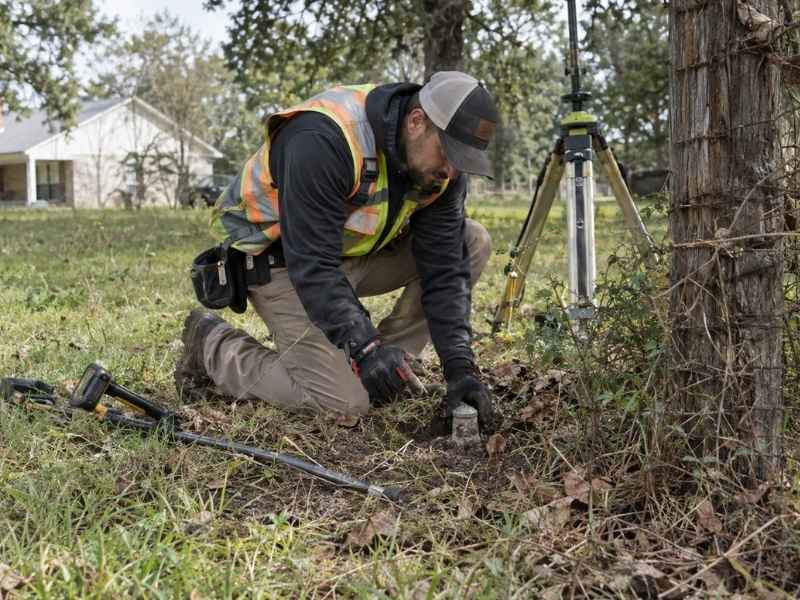
You go looking for the iron pin that marks your property corner, and it’s just gone. Maybe it rusted away. Maybe a mower or a bulldozer took it out years ago. Whatever the reason, a missing marker can feel like your property line markers vanished with it.
It didn’t. The physical marker and the legal boundary are two different things. A missing marker is a common problem, and a professional land surveyor can fix it. This comes up often and across Troup County, especially on older properties where original markers have had decades to disappear.
A Missing Marker Does Not Change the Property Boundary
This is the part worth understanding first. Your property boundary exists as a legal description in your deed. It’s tied to a recorded plat and often to other markers around the property. It doesn’t disappear just because one physical marker does.
Think of the marker as a label, not the boundary itself. The label can fall off, but the property line it was marking is still there, defined by:
- The legal description in the recorded deed
- The recorded plat showing the parcel’s shape and size
- Other surviving monuments on the property or nearby parcels
- Old survey records tied to the original boundary
In older parts, where some properties were platted generations ago, missing markers are common, not rare. A licensed surveyor deals with this often, and the process for handling it is well known.
What a missing marker does mean is that someone needs to figure out where that marker used to be. That takes evidence, not guesswork.
How Surveyors Research a Missing Property Corner
Before anyone heads out to the property, a professional land surveyor starts with research. This groundwork shapes everything that happens in the field later.
Typical research includes:
- Reviewing the current deed and legal description
- Pulling the recorded plat or subdivision map
- Checking for any past surveys of the property or nearby parcels
- Reviewing county records for context, though these are used as reference only
Older deeds in Troup County sometimes describe boundaries using measurements or reference points that don’t line up perfectly with modern survey tools. This isn’t unusual, but it does mean a surveyor has to read old records carefully instead of trusting every number at face value.
This research also flags problems early. If a neighboring deed describes the shared boundary differently, the surveyor needs to know that before ever setting foot on the property.
How Surrounding Evidence Helps Reestablish the Corner Location
Once the paperwork is reviewed, a surveyor searches the property for physical clues that can help pinpoint where the missing corner actually was.
This evidence can include:
- Other surviving iron pins, pipes, or concrete monuments nearby
- Old fence lines or tree lines that may follow an old boundary
- Corners on nearby properties that help confirm a pattern
- Natural features named in older deeds, like a stream or a distinctive tree
A single missing corner rarely stands alone. Most properties have several corners, and the ones that survived can help confirm the pattern and location of the one that’s gone. Distances and angles between known points give the surveyor a framework of math to work from.
In areas with older trees or long-standing fence lines, some of this evidence has been sitting in plain sight for decades. Other times, a marker was completely removed during construction or grading. When that happens, the surveyor has to lean more on math and pattern evidence from the corners around it.
When a Missing Corner Can Be Reestablished in the Field
With research and field evidence gathered, the surveyor figures out the most likely original spot of the corner. This relies on professional judgment as much as measurement.
Georgia surveying practice generally gives more weight to some types of evidence than others. Original monuments and long-standing physical evidence usually carry more weight than measurements alone, though this depends on the details of each case.
A surveyor looks at:
- How well physical evidence matches recorded measurements
- Whether long-standing fence lines or land use support a certain spot
- How the corner fits with the pattern of other corners on the property
- Whether any conflicts with neighboring properties need to be worked out
Once a location is confirmed, the surveyor sets a new monument and writes down the process. This includes a written explanation of the evidence used and the reasoning behind the answer. This creates a clear record that others can rely on going forward.
When Reestablishment Gets Complicated
If evidence is thin, mixed, or goes against a neighbor’s idea of the line, working it out may take longer and could involve a boundary line agreement. In some cases, legal help becomes necessary alongside the survey work.
Verify Property Lines Before Starting New Improvements
If you’re planning to build a fence, add a structure, or make any change near a property line, confirm the real boundary first. This matters even more if a marker is missing or you’re not sure of its spot.
This matters because:
- Building on or over a boundary line can create a legal encroachment
- A missing marker doesn’t mean the boundary is unclear, but it does mean it needs to be confirmed by a professional
- Fights over an assumed boundary can be costly and slow to fix later
- Lenders, title companies, and towns may require confirmed boundary information for permits or financing
If your project has a construction start date, financing deadline, or permit submission tied to boundary confirmation, start the survey process early. This work takes time, especially if a corner needs to be reestablished from limited evidence. Starting early helps avoid delays.
Requirements can vary by property type, lender, town, and project size, so confirm what your specific case needs before assuming an old survey or a rough guess is good enough.
Frequently Asked Questions
Does a missing property marker mean my boundary line is legally unclear?
No. The boundary is defined by your deed, recorded plat, and other evidence, not just the physical marker. A professional land surveyor can usually reestablish the marker’s original spot using that evidence.
How does a surveyor know where to put a new marker if the old one is gone?
Surveyors research deeds, plats, and past surveys, then look for physical clues in the field, like nearby monuments, fence lines, or natural features named in old records. This evidence, combined with professional judgment, points to the most likely original spot.
Can I just guess where my property line is based on an old fence?
This isn’t a good idea. A fence may or may not follow the real boundary. A professional land surveyor can confirm whether a fence line matches the legal boundary or reflects something else, like a past informal deal between owners.