↓
 

LaGrange Land Surveying

Your First Choice for Surveying in Lagrange GA

LaGrange Land Surveying
  • Home
  • ALTA Title Survey
  • Atlanta ALTA Land Survey
  • Boundary Surveying
  • Construction Survey
  • Drone LiDAR Mapping
  • Elevation Survey
  • Land Surveying
  • Topographic Survey
  • Blog
  • Contact Us
Home 1 2 >>

Post navigation

← Older posts

Welcome to LaGrange Land Surveying

LaGrange Land Surveying Posted on September 30, 2016 by LaGrange SurveyorSeptember 4, 2020
Newnan land surveying

Welcome to LaGrange Land Surveying’s website

This site is intended to provide you with information on a Land Surveying Company in LaGrange, GA. If you’re looking for a LaGrange Land Surveyor, you’ve come to the right site. If you’d rather talk to someone about your land surveying needs, please call (706) 407-2722 today. For more information, please continue to read. 

Newnan land surveying

Land Surveyors are professionals who measure and make precise measurements to determine the size and boundaries of a piece of real estate.  While this is a simplistic definition, boundary surveying is one of the most common types of surveying related to home and land owners. If you fall into the following categories, please click on the appropriate link for more information on that subject:

LaGrange Land Surveying services:

  1. I need to know where my property corners or property lines are. (Boundary Survey)
  2. I have a loan closing or re-finance coming up on my home in a subdivision or I’m purchasing a lot or house in a recorded subdivision. (Lot Survey)
  3. I need a map of my property with contour lines to show elevation differences for my architect or engineer. (Topo Survey)
  4. I’ve just been told I’m in a flood zone or I ‘ve been told I need an elevation certificate in order to obtain flood insurance or prove I don’t need it. (Flood Survey)
  5. I’m purchasing a larger tract of land, acreage, that hasn’t been subdivided in the past. (Boundary Survey)

If your needs don’t fall into one of the above, don’t worry, we’ll get to the bottom of it. CALL LaGrange  Land Surveying TODAY at (706) 407-2722 OR better yet, fill out a Contact Form request to discuss your survey needs.

Posted in land surveying, land surveyor | Tagged LaGrange land surveying, LaGrange land surveyor, Land Surveying, land surveyor, land surveyor lagrange, property line survey

Boundary Surveying Helps Unlock Development Potential on Previously Undivided Land

LaGrange Land Surveying Posted on June 25, 2026 by LaGrange SurveyorJune 24, 2026
Survey crew performing boundary surveying on a large undeveloped property to establish legal lot lines for future land development.

Many landowners hold large, single tracts of land that have stayed whole for years or even generations. This type of property often looks simple on paper, but it can hide limits that stop progress. Without clear divisions, the land cannot be sold in smaller parts, financed easily, or built upon in stages. Boundary surveying creates the exact measurements and legal lines needed to change this situation. It turns one large block into a set of defined lots, and opens up new ways to use, sell, or grow the value of the land.

Why Large Undivided Tracts Often Face Development Barriers

Land that has never been divided comes with its own set of problems. It exists as one single unit, and this structure restricts almost every major decision you might want to make. You cannot sell just a section of it to pay for other needs, or give a portion to family members without complicated legal steps. Banks and lenders also look closely at undivided land, because its true usable size and shape are not clearly marked. This makes it harder to get loans for building or improvements.

Local rules add another layer of limits. Most towns and counties have specific standards for how land can be used. A large parcel may not fit neatly into current zoning plans, and officials often ask for clear boundaries before approving any work. Without formal divisions, you cannot apply for permits to build homes, install utilities, or add roads. Even if you want to use part of the land yourself, the lack of defined lines can cause confusion about where your rights end and public or neighboring rights begin.

These barriers do not mean the land has no value. They simply mean the value stays locked away until clear lines are drawn. Boundary surveying removes these blocks by giving the property a clear, organized structure that everyone can understand and accept.

Establishing New Parcel Configurations Through Boundary Surveying

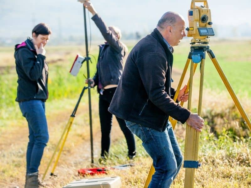
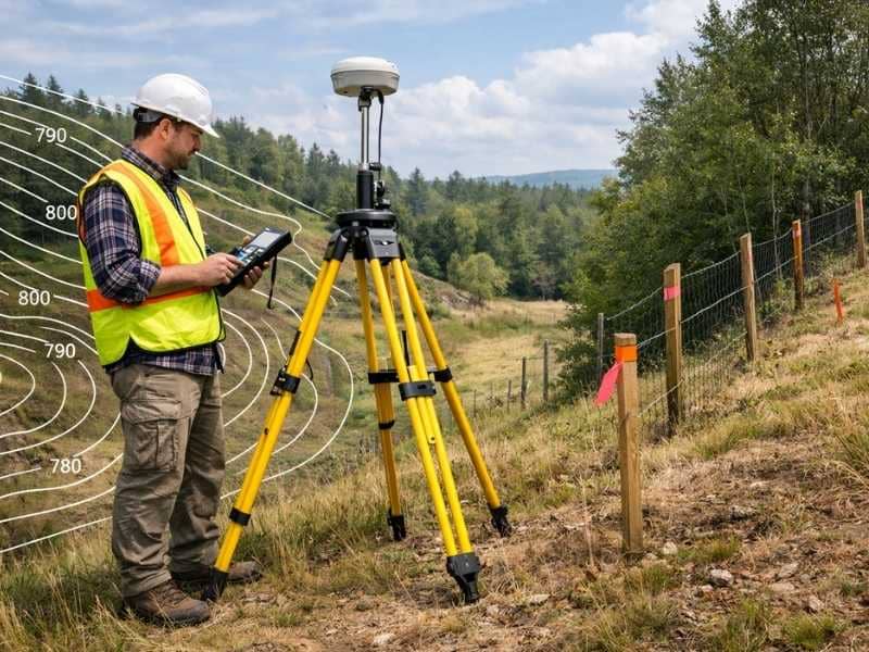
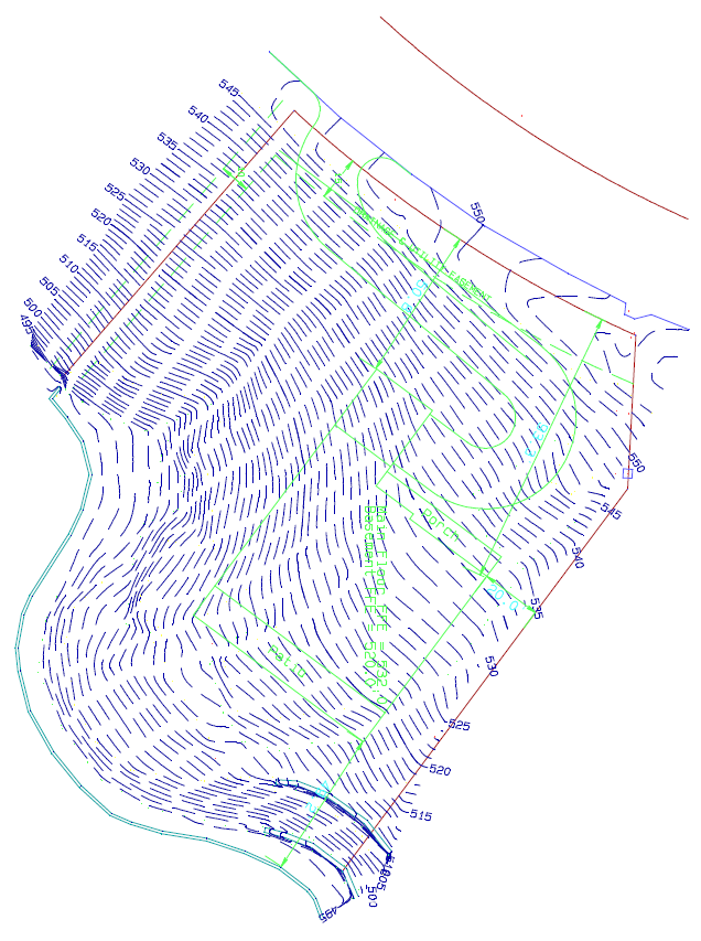
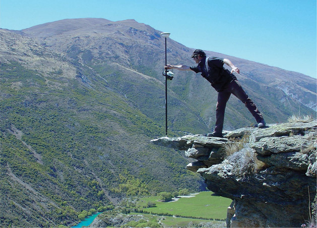
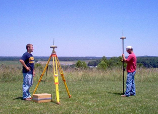
Boundary surveying is the first step to creating separate, legal lots. It starts by finding and marking the true outer edges of the whole property. Surveyors use official records, physical markers, and precise tools to confirm where the land begins and ends. Once they have that outer frame, they work with you to map out how to split the inside into smaller sections.

Each new lot gets its own size, shape, and set of coordinates. These details are recorded in official documents that become part of the land’s legal history. The work follows strict rules so every new parcel meets local standards. This process does not just draw lines on a map. It creates properties that stand on their own, each with its own identity and rights.

When this work is done, the land changes from one unknown block into a collection of clearly defined spaces. This makes it possible to plan exactly what will happen on each lot, whether you build on it, keep it, or offer it for sale.

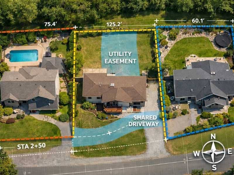
Evaluating Road Frontage Requirements Before Land Division

Nearly every area has rules about how much of a lot must sit along a public road. This measurement is called road frontage. It ensures that every property has safe and legal access for vehicles, emergency services, and utility lines. If a new lot does not meet the minimum requirement, it cannot be approved or used for most types of development.

Boundary surveying measures this distance exactly. It shows how much frontage each proposed lot will have, and whether it fits within local guidelines. If the first plan does not work, the surveyor can suggest small changes to the layout. They might adjust the width or depth of a lot to make sure it meets the rule without wasting usable space.

Checking this early saves time and money. You avoid submitting plans that will be rejected, and you make sure every new lot is ready for approval from the start. This step also helps you see how many usable lots you can actually create, so you set realistic goals for the project.

Supporting Easement Planning for Future Property Access

Sometimes, not every lot can sit directly next to a road. In these cases, the new lots need a legal way to reach the street or connect to water, power, and sewer lines. These designated paths are called easements. They give one property the right to use a small strip of land that belongs to another.

Boundary surveying maps out exactly where these access paths will go. It marks their width, length, and position so everyone knows their location. This work also sets clear rules for how the easement can be used, and who shares responsibility for its upkeep. When easements are drawn and recorded properly, they stop arguments later about who can cross where or who pays for repairs.

A good layout of easements keeps the whole development working smoothly. It makes sure no lot gets trapped without a way in or out, and it keeps space open for the pipes and cables that make modern life possible.

Increasing Property Flexibility Through Strategic Lot Creation

Dividing land with the help of boundary surveying opens up many new choices. Instead of being stuck with one big piece, you gain the freedom to use the land in ways that fit your current and future needs. You can sell one or more lots to raise funds, while keeping others for personal use. You can also build on one section at a time, spreading out costs and work over several years.

For families, this division makes it easier to pass property to the next generation. Each person can receive a clear, defined lot without the confusion of shared ownership. For investors, divided land often has a higher total value than one single parcel. Smaller lots attract more buyers and can be developed faster than large blocks.

Every new lot you create comes with its own legal description and future. This flexibility lets you adapt to changing plans, market conditions, or personal goals. Boundary surveying does more than just draw lines, it gives the land a clear path forward.

Frequently Asked Questions

What is the purpose of boundary surveying when dividing land?

It finds and marks the exact edges of the whole property and maps out where new dividing lines will go. It creates measurements and records that are accepted by local offices, banks, and buyers. This work turns one large tract into separate, legal lots.

Can a boundary survey help create new legal parcels?

Yes. The information from the survey becomes the base for official documents that list each lot’s size, shape, and location. When these records are filed, each new lot becomes its own legal property with its own rights and description.

Why is road frontage important during land division?

Local rules require a minimum amount of frontage to make sure every lot has safe access to roads and public services. Boundary surveying measures this distance for each proposed lot, so you know right away if the plan meets the standard.

How do easements affect newly created lots?

Easements give legal rights to use a small part of land for access or utilities. They are marked clearly during the survey, so owners know where these paths sit and how they can be used. Proper planning prevents conflicts and keeps every lot connected to what it needs.

What benefits can come from dividing previously undivided land?

It gives you more ways to use, sell, or build on the property. It makes financing easier, increases total value, and simplifies transfers to family or other owners. Each new lot becomes a flexible asset that fits your plans for the future.

Posted in boundary surveying | Tagged boundary surveying

Topographic Survey vs. Boundary Survey: Key Differences Explained

LaGrange Land Surveying Posted on May 29, 2026 by LaGrange SurveyorMay 27, 2026
Land surveyor performing a topographic survey and boundary survey using GPS equipment on a sloped property

A topographic survey maps the physical features of a piece of land, such as hills, slopes, trees, and drainage patterns. A boundary survey maps the legal edges of a property. Both are performed by licensed land surveyors, but they serve very different purposes and are used at different stages of owning or developing land.

What Is a Topographic Survey?

A topographic survey measures and records the natural and man-made features on a piece of land. It shows changes in elevation, the location of structures, trees, water bodies, and other physical details. Engineers and architects use topographic surveys to plan construction projects before any building begins.

A topographic survey gives a detailed picture of what the land looks like from the ground up. It captures elevation changes using contour lines on a map. Each contour line connects points of equal elevation, so the closer the lines are together, the steeper the slope.

Here is what a topographic survey typically includes:

  • Elevation changes and contour lines across the property
  • Location of trees, shrubs, and other vegetation
  • Existing structures such as buildings, fences, and retaining walls
  • Water features including streams, ponds, and drainage channels
  • Utility lines, roads, and driveways on or near the property
  • Soil and rock formations when relevant to a construction project

Topographic surveys are especially important for flood planning. Engineers use them to study how water moves across a property during heavy rain. According to FEMA, accurate elevation data is one of the most critical factors in assessing flood risk for any parcel of land.

What Is a Boundary Survey?

A boundary survey determines the exact legal boundaries of a property. It identifies the corners of your lot, confirms property lines, and produces a legal document called a plat or survey map. Mortgage lenders, title companies, and local governments often require a boundary survey before a property is sold, developed, or subdivided.

A boundary survey answers one core question: where does your property begin and end?

Licensed land surveyors research public records, deeds, and historical documents before going out into the field. They then use GPS equipment, total stations, and other tools to locate property corners and measure the exact dimensions of the lot.

Here is what a boundary survey includes:

  • Exact location of all property corners and lines
  • Measurements of the lot’s length and width on all sides
  • Any overlaps or gaps with neighboring properties
  • Recorded easements that cross the property boundaries
  • Encroachments, such as a neighbor’s fence or structure crossing the line
  • A legal survey map filed with the county or local records office

According to the National Society of Professional Surveyors (NSPS), boundary surveys are the most commonly requested type of land survey in residential real estate. They are a standard part of buying or selling property in most U.S. states.

Key Differences at a Glance

FeatureTopographic SurveyBoundary Survey
Main purposeMaps physical land features and elevationDefines legal property lines
Who uses itEngineers, architects, contractorsHomeowners, buyers, lenders, attorneys
What it showsHills, slopes, trees, water, structuresProperty corners, dimensions, encroachments
When it is neededBefore design or construction beginsDuring real estate transactions or disputes
Legal document producedEngineering base mapRecorded plat or survey map
Typical cost range$500 to $2,500 or more$400 to $1,500 depending on size and complexity

When Do You Need a Topographic Survey?

You need a topographic survey when you are planning to build, remodel, or develop land. It is required when designing drainage systems, grading a yard, adding a swimming pool, planning a road, or applying for certain building permits. Architects and civil engineers almost always require one before starting a project.

Here are the most common situations that call for a topographic survey:

  • New home construction. Builders use a topo survey to understand how water drains away from the home and how to properly grade the lot.
  • Swimming pool or outdoor structure installation. Contractors need to know the slope and soil conditions before digging.
  • Landscaping and grading projects. A topo survey helps designers plan terraces, retaining walls, and water drainage.
  • Road or driveway design. Engineers use elevation data to ensure the road drains properly and is safe to drive on.
  • Subdivision or land development. Local governments typically require a topographic survey before approving development plans.
  • Flood zone assessment. A topo survey provides accurate elevation data used in flood risk studies and FEMA map amendments.

When Do You Need a Boundary Survey?

You need a boundary survey when buying or selling property, settling a neighbor dispute, applying for a building permit, refinancing a home, or subdividing land. It confirms exactly where your property lines are and protects you from costly legal conflicts.

Here are situations that typically require a boundary survey:

  • Buying a home or vacant land. A boundary survey confirms that you are buying exactly what the seller says you are.
  • Building a fence, garage, or addition. Most local building departments require proof of property lines before issuing permits.
  • Neighbor disputes. If you and a neighbor disagree about where the property line falls, a licensed surveyor’s findings are legally accepted.
  • Refinancing your mortgage. Some lenders require an updated survey to verify property dimensions before approving a refinance.
  • Splitting or subdividing land. Any division of land requires a new boundary survey to create legal lot descriptions for each new parcel.
  • Estate planning or inheritance. When land is passed to heirs, a boundary survey ensures each portion is clearly defined.

How Much Do These Surveys Cost?

A boundary survey typically costs between $400 and $1,500 for a standard residential lot. A topographic survey usually ranges from $500 to $2,500, depending on the size and complexity of the land. Rural or heavily wooded properties cost more because they take longer to survey.

Several factors affect the final price of either survey:

  • Property size. Larger lots require more time and equipment to survey.
  • Terrain and vegetation. Steep slopes, dense trees, or thick brush slow the process and increase labor costs.
  • Availability of existing records. If older deed descriptions are unclear or conflicting, surveyors spend more time researching before fieldwork begins.
  • Location. Urban areas with higher costs of living generally charge more for surveying services.
  • Survey purpose. Surveys needed for legal filings, subdivisions, or ALTA title insurance carry additional requirements that raise the price.

Getting an accurate quote from a licensed land surveyor is always the best first step. Most surveyors offer free estimates based on your address and the purpose of the survey.

Can You Get Both Surveys at the Same Time?

Yes. In many cases, a land surveyor can perform a boundary survey and a topographic survey together in a single site visit. Combining both surveys saves time and money compared to scheduling them separately, and the results are often delivered as one combined document used for design and permitting.

A combined survey is especially useful when you are buying land and planning to build on it right away. The boundary survey confirms what you own, while the topographic survey gives your builder everything needed to design your project correctly.

Ask your land surveyor upfront whether a combined survey fits your needs. Many firms offer this as a standard service for residential construction projects.

Frequently Asked Questions

Which survey do I need if I am just buying a house? 

Most home buyers need a boundary survey. It confirms the legal edges of the property, shows any encroachments, and is often required by the title company or lender. A topographic survey is not typically needed unless you are planning to build or develop the land.

Does a topographic survey show property lines? 

No. A topographic survey focuses on physical land features and elevation changes. It does not define legal property boundaries. For that, you need a separate boundary survey.

How long does each survey take to complete? 

A boundary survey for a standard residential lot usually takes one to three days for fieldwork, plus additional time for research and drafting the final map. A topographic survey of the same lot typically takes a similar amount of time. Complex or large properties take longer.

Is a topographic survey the same as a topo map? 

Not exactly. A professional topographic survey is a precise, legally documented measurement of your specific property. A general topo map, such as those from the USGS, covers large geographic areas and is not specific or detailed enough for construction or permitting purposes.

Who performs topographic and boundary surveys? 

Both surveys are performed by licensed land surveyors. In the United States, surveyors must be licensed by the state in which they practice. Always verify that your surveyor holds a current, active license before hiring them for any survey work.

Posted in land surveying | Tagged boundary survey, topo surveying

What Homeowners Should Know About a Property Easement 

LaGrange Land Surveying Posted on May 28, 2026 by LaGrange SurveyorMay 27, 2026
Aerial view of a property easement showing utility access and shared driveway boundary lines between residential homes

A property easement is a legal right that allows another person, company, or government agency to use a specific part of your land for a set purpose. You still own the land, but you cannot always control how that portion is used. Easements are legally binding, they stay with the property when it is sold, and they can affect what you are allowed to build or change on your land.

What Is a Property Easement?

A property easement is a non-ownership legal right to use part of someone else’s land. The person who holds the easement does not own the land. They simply have permission to use a defined portion of it for a specific reason. That right is recorded in public records and passes to the next owner when the property is sold.

Easements are more common than most homeowners realize. According to the American Land Title Association, easements appear in millions of real estate transactions every year and are among the top five issues found during property title searches. In the United States, utility easements alone affect an estimated 60 to 70 percent of all residential properties.

It is important to understand that an easement does not give anyone ownership of your land. It only grants permission to use a specific area for a specific purpose. If you sell your home, the easement stays in place for the next owner. The new buyer inherits both the property and any easements attached to it.

Easements matter because they can affect:

  • What you are allowed to build or plant on part of your land
  • Whether a utility company can enter your property without asking
  • How much a buyer may be willing to pay for your home
  • Whether a sale can go through without legal complications

Common Types of Property Easements

The most common types of property easements are utility easements, access easements, drainage easements, conservation easements, prescriptive easements, and easements by necessity. Each type serves a different purpose and comes with different rules about what the easement holder is allowed to do.

Utility Easements

Utility easements give electric, gas, water, sewer, and cable companies the right to install and maintain their lines and equipment on your property. These are the most common type of easement in the country.

  • They typically run along the rear or side of a residential lot.
  • You cannot build a permanent structure, such as a shed or garage, directly over a utility easement.
  • The utility company has the right to enter, dig, and do maintenance work without needing your permission first.

Access Easements

An access easement gives a neighboring property owner or the public the right to cross your land to reach another location. This is also called a right-of-way easement.

  • These are common in rural areas where one property has no direct access to a public road.
  • A shared driveway between two homes is a familiar example.
  • The terms of the easement spell out how the access can be used and who is responsible for upkeep.

Drainage Easements

A drainage easement allows water to flow across your property through a natural or constructed channel.

  • You will often find these near low-lying areas, creeks, or retention ponds.
  • Local governments frequently require drainage easements when new neighborhoods or roads are built.
  • You cannot block or redirect the water flow within the easement area.

Conservation Easements

A conservation easement is a voluntary agreement between a landowner and a land trust or government agency to protect the land from certain types of development.

  • The landowner keeps ownership but agrees to limit what can be built on the land.
  • The IRS allows tax deductions for conservation easements, in some cases up to 50 percent of adjusted gross income.
  • These easements are permanent and will apply to every future owner of the property.

Prescriptive Easements

A prescriptive easement forms when someone has used a portion of your land openly, continuously, and without your permission for a period defined by state law, often between 10 and 20 years.

  • This type is similar to adverse possession but does not transfer ownership.
  • Posting “No Trespassing” signs or physically blocking access can prevent a prescriptive easement from forming.

Easements by Necessity

A court can grant an easement by necessity when a property has no legal way to reach a public road.

  • This can happen when a parcel is created without its own road access.
  • Courts may impose this easement even if the neighboring landowner objects.

How Easements Are Created

Easements are created through written agreements, court orders, long-term use, or legal necessity. Any formal easement must be recorded with the county to be enforceable against future buyers.

The four main ways an easement is created:

  1. Express grant. Both parties sign a written agreement, which is then recorded with the county clerk.
  2. Reservation. A seller keeps an easement over land they are transferring to a buyer.
  3. Prescription. Long-term, open use of another person’s land without permission creates an easement by law.
  4. Necessity. A court orders an easement when a property cannot be reached any other way.

How an Easement Can Affect Your Property Value

Easements can reduce a home’s market value by 5 to 40 percent, depending on the type and location. Small utility easements along the rear of a lot usually have little impact. Larger access or conservation easements that limit what you can build may lower the value significantly.

The Appraisal Institute requires licensed appraisers to factor easements into their market value assessments. Here is a general guide to how different types affect value:

Easement TypeEstimated Value Impact
Utility easement along rear or sideMinimal, up to 5 percent reduction
Access or right-of-way easement5 to 20 percent reduction
Drainage easement over buildable area5 to 15 percent reduction
Conservation easement20 to 40 percent reduction

If you are buying a property, always ask whether any easements exist before making an offer. The presence of an easement is not always a dealbreaker, but you should know what you are agreeing to before you sign.

How to Find Out If Your Property Has an Easement

You can find out if your property has an easement by reviewing your deed, checking your title insurance policy, searching county land records, or hiring a licensed land surveyor to conduct a boundary or ALTA survey. Easements are recorded in public records and will appear on a professional survey.

Steps to check for easements on your property:

  1. Read your property deed. Easements are often described in the legal description section near the back of the document.
  2. Review your title insurance policy. Your title policy lists all known easements that existed at the time of purchase.
  3. Search county records. Most county clerk or recorder offices have searchable online databases. You can look up your parcel by address or parcel number.
  4. Request an ALTA survey. This is the most thorough survey type and is required to reveal all recorded and visible easements on a property.
  5. Hire a licensed land surveyor. A surveyor will physically locate easements on the ground and mark them on a legal map of your property.

If you are buying a home, request a survey before closing. A standard title search alone may not catch every easement, especially older ones that were never formally recorded.

Can an Easement Be Removed?

Yes, an easement can be removed, but doing so is a legal process. The most common methods are a written release from the easement holder, a merger of both properties under the same owner, abandonment, expiration, or a court order. Any removal must be recorded with the county to be legally effective.

Here is how each method works:

  • Written release. The easement holder signs a formal agreement giving up their rights. Both parties must record the release with the county.
  • Merger. If the same person comes to own both the property with the easement and the property that benefits from it, the easement ends automatically.
  • Abandonment. If the easement holder stops using it and clearly shows they have no intention of using it again, a court may find it abandoned.
  • Expiration. Some easements are created with an end date. Once that date passes, the easement is no longer valid.
  • Court order. If an easement is being used beyond what it was intended for, a court can modify or terminate it entirely.

Removing an easement always requires updating the property deed and filing the change with your county recorder’s office. Consulting a real estate attorney is strongly recommended before starting this process.

Frequently Asked Questions

Does an easement give someone the right to own my land? 

No. An easement is only a right to use a specific portion of your land for a defined purpose. Full ownership stays with you. The easement holder cannot sell the land, transfer title, or build permanent structures in the easement area unless the original agreement specifically allows for it.

Do I have to tell a buyer about an easement when selling my home? 

Yes. Most states require sellers to disclose all known easements as part of the property disclosure process. Failing to disclose can create legal liability after the sale is completed.

Can I put a fence on part of my property that has an easement? 

It depends on the type of easement. Utility easements usually prohibit any permanent structure, including fences. Some access easements permit a fence with a gate. Always read the original easement document carefully and speak with a licensed surveyor or real estate attorney before building near an easement area.

Who takes care of the land within an easement? 

This depends on the terms of the easement. Utility companies maintain their own infrastructure within utility easements. For shared access easements, maintenance responsibilities are usually spelled out in the agreement. When nothing is written down, disputes over upkeep are common and may need to be settled through legal action.

How long does an easement last? 

Most easements are permanent and continue indefinitely with the land. Some are created with a fixed end date or a condition that, once met, automatically ends the easement. Always read the original document to understand the specific terms that apply to your property.

Posted in boundary surveying | Tagged boundary survey

What Is A Land Surveyor?

LaGrange Land Surveying Posted on May 9, 2020 by LaGrange SurveyorApril 1, 2020
land surveyor

land surveyor

A Land Surveyor is essential whenever you plan on building a house, buying or selling a property, or dividing your property amongst your children. Many land surveyor made it down to history. In fact, three of the four faces carved in Mt. Rushmore are land surveyors (Presidents George Washington, Thomas Jefferson and Abraham Lincoln were all three surveyors, Teddy Roosevelt was not.). Others popular names were Daniel Boone, Meriwether Lewis and William Clark (Lewis & Clark), Sir George Everest, Charles Mason & Jeremiah Dixon (of the Mason-Dixon Line fame) and author Henry David Thoreau practiced for a time in Concord, Massachusetts.

What is a Land Surveyor?

A land surveyor is a person with the academic qualifications and technical expertise to measure and plot the lengths and directions of boundary lines and the dimensions of any portion of the earth’s surface (including natural and other structures). That definition is quite a mouthful, but in actuality the field of surveying (geomatics) includes many other facets.

If you plan to purchase a lot, build your dream house, divide your property to your children, or simply want to know the details of a land property, a land surveyor is the best person to help you out. A land surveyor locates the boundary of your property and the location of your home within that boundary to determine if there are any encroachments by your neighbors onto you or vice versa. Common encroachments are fences, driveways, etc.

These days a land surveyor in the United States is regulated and licensed by the various state governments. In Georgia, the Georgia State Board of Licensure for Professional Engineers and Land Surveyors was established in 1935 to protect the public.  A land surveyor’s duty is “to safeguard life, health, and property, and to promote the public welfare by providing for the licensing and regulation of persons in the practices of engineering and land surveying. This purpose is achieved through the establishment of minimum qualifications for entry into the professions of engineering and land surveying, through the adoption of rules defining and delineating unlawful or unethical conduct, and through swift and effective discipline for those individuals or entities who violate the applicable laws or rules.”

How to become a land surveyor?

As of 2007, a newly licensed land surveyor is required to finish a four year degree in surveying or a closely related field, a four to eight years of on-the-job training under a licensed practicing surveyor. In addition to that, licensed land surveyors are mandated to attend 15 hours of continuing education annually to ensure that they are kept updated with the new know-hows that would help them on their professional growth.

What does a land surveyor do?

As part of a standard lot or mortgage survey of a property, expect your land surveyor to review tax maps, aerial maps, deeds, subdivision plats, zoning ordinances, subdivision regulations and possibly even flood maps. For a typical lot survey, the subdivision plat is the most important of these because it tells the exact dimensions of your lot and the relative location of your property corners. The surveyor uses this to locate and/or re-establish your property corners.

In the field, a land surveyor will search for your property corners along with some of your neighbors’ corners. If yours can’t be found, they’ll measure the distances and angles between all of the points, locate the improvements on your property, including your house, pool, out-buildings, retaining walls, fences, driveways, sidewalks, and other home improvements. Other improvements like sanitary sewer mains, storm drainage ways, overhead power lines and the like are located because these might indicate an easement across the property. The plat should show these, but may not in all cases.

Once all of the field information is gathered, the crew chief takes the field notes and prepares a preliminary sketch of the work. This is passed along to a draftsperson who prepares the final outline for your use. The draftsperson will check all of the maps mentioned earlier to make sure that all building setback lines and easements are shown on the draft. The surveyed distances and directions are compared to the plat distances and directions as well. Any discrepancies or encroachments are shown on the drawing. Your lawyer may use the draft to determine if any other legal work is needed during the closing. The mortgage company or the bank may also use the survey for their records.

So now, what do you have for your money. You have a drawing which shows your house on your lot. You should have stakes and/or flagging by all of your property corners. Make sure you know where they are located. The actual corner is marked by an iron pin or pipe of some sort. (The type of monument should be shown in your survey drawing.) You might also want to take a look at them at least once a year to make sure they’re still there. (Even animals mark their territory more often than that.)

For more specific information about what type of survey you need, Contact your local land surveyor at LaGrange Land Surveying at  (706) 407-2722 or fill out a Contact form request.

Posted in land surveyor, topo surveying | Tagged boundary survey, LaGrange land surveying, LaGrange land surveyor, land survey, Land Surveying, land surveyor

Explanation of a Topo Surveyor

LaGrange Land Surveying Posted on April 27, 2020 by LaGrange SurveyorApril 1, 2020
topo surveyor

Topo Surveying and Topo Surveyor

topo surveyor

A Topographic Surveyor also known as a Topo Surveyor collects the survey data to locate man-made and natural marks and its elevations on a particular portion of land. It normally comprises any man-made underground marks such as utility lines. It will also illustrate ground level installations such as utility poles, buildings, walls, and many other significant installations.

The utilization of standard topographic surveying procedures are commonly employed to provide accurate measured plan of terrain. It is also used during the mapping and graphing phases of projects to blueprint the locations and layout of the installations, road, buildings, and many other engineering and architectural projects in the construction industry.

Why Hire a Topo Surveyor?

The purpose of getting a Topo Surveyor to do topographic survey is to obtain an accurate trace and documentation of the present state of a parcel of land that will be constructed on; either a building, a wall, or any other construction activity. The design engineers make use of the topo survey as they plan the design and then the proposal of the final surface.

It is important to have this plan as this allows the Engineer compute, analyze, and estimate the amount of earth work that might be required. The Engineer will also be able to balance the amount of earth work to minimize the dirt to be taken off and on the construction site. The architect also makes use of the topo survey the same way as the Engineer does.

Additionally, the architect may plot the surface in 3D to picture out the finished look with the improvements he might add. This plot may be presented to the construction owner, building owner, or the land owner before the actual construction takes place. An accurate topo survey is of big help to ensure the installations and improvements fits in on the site within its boundaries.

Common Methods that a Topo Surveyor use

The two common methods of doing a topographic survey are Aerial Topo Survey and Conventional Topo Survey. How the topographic survey done would vary on the method the Topo Surveyor use. It is important that a topo surveyor know how to carry out both in any circumstances. So if you will need one, make sure he is professional and experienced both methods.

An Aerial Topographic Survey is done on the airspace. It is taken either in a helicopter or in an airplane at a defined distance above the ground level. Aerial photos of the ground surface are then taken and examined by the topo surveyor. This will allow him to envisage the ground surface through the structure of a stereo pair. By looking at the two overlapping aerial photos, the vantage points are determined.

A Conventional Topographic Survey is done when there is a need to get the accurate contour interval and spot elevations. The Aerial Topographic Survey is limited in the precise vertical and horizontal point location of the ground surface. These are just simplified elaboration of the two methods of topographic survey to provide you an overview. Read and research to learn in depth about them or ask a topo surveyor.

If you need a Topo Survey, Please call LaGrange Land Surveying today at (706) 407-2722  or fill out a contact form request for more information concerning your land surveying needs.

Posted in topo surveying | Tagged lagrange topo survey, Land Surveying, land surveyor, topo survey lagrange, topo surveying, topo surveyor, topographic survey, topographic surveyor

Learn The Basics of Boundary Surveying LaGrange

LaGrange Land Surveying Posted on April 17, 2020 by LaGrange SurveyorApril 1, 2020

Investing in land or real property may be the most expensive investment you’ll make in your lifetime. Thus, it is wise to learn a little more about real estate and be aware of the significance of boundary surveying before making such investments.

Boundary Survey Defined

Let’s first define boundary surveying. Boundary surveying is the verification of property lines of a parcel of land as detailed in the description in the deed. It may also show all the structures found on the property including any easements and encroachments, and also the restrictions imposed by local governing authorities.

To avoid unnecessary expenses and free you from frustrations brought by unexpected lawsuits, it is vital to conduct a boundary survey in the LaGrange area before purchasing or selling a parcel of land. A survey is also required before subdividing a lot, building structures or improving the property to make sure that you don’t end up having to move a building or resolve a boundary dispute with your neighbors.

Other Uses of a Boundary Survey

A boundary survey may also help you identify whether you are located in a floodplain, which would mean you are required to obtain flood insurance. A boundary survey in LaGrange is also very helpful in completing the requirements for a mortgage loan from a lending institution, which includes checking the accuracy of the description of the property in the deed and the presence of improvements, easements, and any encroachments.

land surveyingBoundary Survey Costs

The cost of a LaGrange boundary survey depends on several factors, some of which can only be determined once the work has begun. Some factors are size of the lot, the terrain, the vegetation type, the season of the year (which greatly affects the growth of vegetation). The work begins with the deed research that can be started with the deeds or abstracts that the landowner may possess and can extend as much as going to the courthouse and putting together the pieces of the deed. The job could get more complex if the property involved has been passed on through several owners over the years. Some may have sold off a portion of the parcel or may have added to adjacent lots. The more of these additions and subtractions can significantly impact the complexity of the work to be done, which consequently adds to the survey cost.

Boundary Survey Drawing

After the boundary survey is done, a landowner should expect to get a survey drawing that contains a sketch of the survey findings and the legal description of the property. It is also expected that proper markings of the property lines and corners have been placed, which are usually bright-colored ribbons or paint, wooden stakes, or concrete monuments. Others survey projects may or may not include a drawing or report, depending on the services agreed upon.

Posted in land surveying | Tagged boundary, boundary survey, boundary survey lagrange, boundary surveying, surveying

Licensed Land Surveyor: Using GPS to Track You – Is It Real?

LaGrange Land Surveying Posted on April 11, 2020 by LaGrange SurveyorApril 1, 2020
licensed land surveyor

A licensed land surveyor trusts his GPS system like  his gun in a battlefield. Though it sometimes do not provide all the info that you may need, it is nonetheless very helpful in producing an accurate boundary survey.

Many have heard of “Big Brother” being able to track our movements. One of my favorite TV shows is “Person of Interest” where a secret machine keeps track of all conversations and people’s “criminal intent” in order to help the heroes stop the crimes before they happen.

While I’m SURE that there are tracking capabilities in most cell phones and different government agencies CAN track our locations, we might be a ways away them being able to determine criminal intent.  But there IS a recent application in England that I found very interesting.

Nestle (yes, the chocolate company) is placing GPS Trackers in six KIT KAT bars in their aptly named “We’ll Find You” marketing campaign in the UK. When the person opens the package it notifies KIT KAT and the prize delivery team will find them within 24 hours and present them with a check for £10,000 (about $16,000.) See the article here.

Just about all new type cell phones, all smart phones, iPads and other tablets, lots of cars (more than you think), public transportation vehicles, golf carts, and watches have GPS devices in them now days. Another place they are, and rightly so, are in ankle monitors used by law enforcement. But, what you might not realize is that the electronic devices mentioned above can work just like the ankle monitor. Now, while it is true that you can disable the GPS tracking device in your cell phone or tablet, that doesn’t give all of us complete comfort in walking around with these devices on us.

Now, I’m not trying to be a conspiracy wonk here, but it is POSSIBLE that this could be taken advantage of by well-meaning agencies. And, as we know, law enforcement can make mistakes in identifying the correct suspect.  Of course, as a licensed land surveyor myself, I WANT emergency services to be able to find me if and when I need their service, so this is a double edged sword. Most of us probably have nothing to worry about in this regard, but if you worry about this sort of thing, it could keep you up at night.

licensed land surveyor

Even as a licensed land surveyor, having used GPS technology in land surveying for almost 20 years, I still trust them more than I should.

One example is when I was in an unfamiliar town my GPS navigation device told me to take a “road” to the right. I slowed down and attempted to turn but it was a power line.  Not wanting to believe that Gizell was wrong (yes I named her), I went to the next street and turned and tried to find the “road” further back. I ended up driving down the sandy power line, which turned into a bike lane until I was finally stopped by a gate. As I backed down the bike lane looking for a turn-around spot I thought, “maybe this wasn’t a road and maybe my GPS device is fallible.” Of course, I soon justified Gizell by recalling that a human had to “digitize” the roads in and she just did what they programmed her to do.

If you need to turn off your GPS tracking device in order to sleep tonight, call your device’s customer service line and stay away from KIT KAT bars. If you would like to find out how GPS surveying technology can help you in surveying your property boundary, call a Licensed Land Surveyor at LaGrange Surveying at (706) 407-2722.

Posted in land surveyor, topo surveying | Tagged LaGrange land surveying, Land Surveying, land surveying Lagrange, land surveyor, licensed land surveyor, licensed land surveyor LaGrange

What is an ALTA Title Survey?

LaGrange Land Surveying Posted on April 2, 2020 by LaGrange SurveyorApril 1, 2020
ALTA Title survey

ALTA stands for American Land Title Association. ALTA Land Surveys are similar to a boundary or lot survey of a piece of land. However, an ALTA Title Survey has further requirements for the land surveyor as he executes the survey because of the high-dollar value of the property.

ALTA Survey Standards Lead to Consistency

ALTA SurveyMost states have widely varying standards for surveying. Thus, ALTA Surveys follow a national standard for surveying aimed to generate consistency regardless of the location of the survey. This type land survey is usually done on a multi-family residential or commercial site and when the owner and/or lender are from different states. But more often than not, it is prepared for commercial properties because it provides the information needed in order to insure the title to the land. Commercial developments may also require improvements to a high level that is also obtained through this survey.

ALTA Title Surveys are very complex and are commonly more costly than surveys following state standards because it takes more time and effort.

Costs for such surveys could be up to 50% – 200% more than a similar boundary survey. It is also important to note that the more restrictive standard is followed in the survey if the state standard is more restrictive on a certain aspect than the ALTA standard. An ALTA Title Survey must show all data including boundary lines, main building location and all its improvements, location of ancillary buildings, rights-of-way, and easements or access rights by utility services such as water, telephone, gas, railway and other utilities. A helpful tip in outlining the scope of services of the land surveyor is to thoroughly go over the elements of “Table A – Optional Survey Responsibilities and Specifications”.

ALTA Survey Requires Title Committment

Before an ALTA Title Survey can be completed, there must be a current title commitment. This is where the land surveyor will refer for the legal description of the property and all legal encumbrances or exceptions. The areas of ownership, encumbrances, and improvements will be presented graphically including encroachments, if there is any.

All the affected parties; the buyer, seller, lender, and title insurance company must be indicated on the ALTA Title Survey certificate. The land surveyor and the title insurance company must closely work together in order to illustrate comprehensively all matters affecting the ownership of the land and improvements.

Requirements for an ALTA/ACSM Land Title Survey as detailed by the American Land Title Association, National Society of Professional Surveyors and the American Congress on Surveying and Mapping is certainly met through an ALTA Title Survey.

If we can help you with an ALTA Title Survey in the future, please don’t hesitate to contact us at LaGrange Land Surveying at (706) 407-2722 or fill out our contact form by clicking the link.


Posted in ALTA Title Survey, land surveying | Tagged ALTA Survey, ALTA Title survey, ALTA Title survey LaGrange, LaGrange ALTA Title Survey

What You Need to Know About Land Surveying

LaGrange Land Surveying Posted on November 8, 2019 by LaGrange SurveyorApril 1, 2020
land surveying

land surveying

What is Land Surveying?

Land surveying is the art and science of accurately measuring parcels of land. Measurements such as dimensions, lengths, boundary lines, including structures within the area are all precisely determined through a land survey. These measurements are used to establish land maps, boundaries for ownership or for governmental purposes. It is a detailed study of every physical and cultural property of the land, whether above or beneath it, to illustrate it in usable form. 

 Data is gathered through observations, research, field measurements, and data analysis for establishing property boundaries. Records from previous surveys and government records will strengthen the reports made after the survey. 

What covers land surveying?

A land survey is classified according to the purpose or why the survey is being performed. Some of the common types of land survey are boundary surveys, topographic surveys, partition or subdivision surveys, flood elevation survey, property line adjustment survey, and extended title insurance coverage survey. 

Other services such as mapping, construction layout surveys, judicial surveys, registered land surveys are all part of land surveying. It is an essential element in every development of the environment especially in the fields of construction, transport, communication, mapping, and most especially in the definition of legal boundaries for ownership.

The key component in the field of land surveying is the land surveyor. A land surveyor is a person that takes charge of every activity that transpires during a land survey. It is the surveyor who makes the research and data gathering and even interpretation and analysis of all data wherein translation of all data gathered is crucial and should be checked, attested, and sworn in the law to be true and correct. It is important then for you to choose a land surveyor with the highest degree of expertise and who can assume responsibility for the complex tasks at hand. It should be emphasized that only a surveyor who has knowledge of the elements of geometry, trigonometry, engineering, mathematics, physics, and the law are expected to have the best land survey outcomes.

Land surveying – dated back in history

Land surveying is a profession as old as the Egyptian times yet its importance to the human race still lives on. It is the best method to settle disputes over land ownership, it gives a clear picture of what buildings are suited to be constructed in a given land area, and it’s a convenient way to determine the exact dimensions of real estate to be purchased or sold. 

Optimum potential of the land you own can only be defined once you have a land survey. Whether you are planning to put it on the market, or should you want to use it for commercial purposes, a land survey must back you up if ever questions regarding everything about the land arise. Land surveying will provide a sense of security and peace of mind to every land owner and even to the future buyers.

Land surveying will always be an integral part in protecting real estate and upholding of laws governing the utilization and distribution of your land assets. 


Call LaGrange Land Surveying today at  (706) 407-2722  or fill out a contact form request for more information concerning your land surveying needs.


Posted in land surveying | Tagged boundary survey lagrange, LaGrange ALTA Title Survey, LaGrange land surveying, LaGrange land surveyor, Land Surveying, land surveying Lagrange, land surveyor, land surveyor lagrange, licensed land surveyor LaGrange

GPS and Land Surveying

LaGrange Land Surveying Posted on February 22, 2017 by LaGrange SurveyorApril 1, 2020
land surveying

Land surveying is a profession that greatly utilize the GPS system.

land surveying

Today, man-made constellations are in orbit. Their purpose is to provide instant, exact and global positioning information. This global positioning system of GPS is revolutionizing the modern construction sites, automating and guiding land surveying equipment, providing instantaneous circles and volume gap, simplifying total and controlled surveys. Nearly everyone involved in the land surveying and construction industry has heard something about satellite positioning technology or maybe you or someone you know is already using it. Whether an operator or a casual observer, there are still many questions about how this exciting system really works.

These positioning satellites don’t stay in one place like the stars; they orbit the earth about twice a day. Constantly transmitting uniquely identified radio signals that can be perceived by specialized units on earth. These signals are used to precisely measure the distance to the receiving instrument from each satellite visibly overhead.

Just as stars have exact locations in the sky, the locations of the GPS satellites are also defined, becoming orbiting reference points. Using a process based on triangulation, a GPS receiver processes the signals from multiple satellites to compute an accurate position on Earth, which is why it is widely use in land surveying.

For mobile applications that require high accuracy, such as three dimensional machine control, there are two requirements that must be met. First, the signals from a minimum of five satellites must be received at all times. And second, those five satellites must be distributed across the sky. This is called Dilution of Precision or DOP. The simple rule of thumb is this, the more satellites received the better your system will perform.

land surveying

All land surveying receivers incorporate standard GPS tracking technology; unfortunately the GPS satellite constellation alone cannot continuously make the minimum requirement of accurate mobile positioning. For any given location, there are times in a day when there are less than five available satellites or very poor DOP.

Now, consider a land surveying job site with trees, buildings, or other obstructions when satellite receptions are easily be further reduced. All land surveying GPS receivers suffer this same problem because they all use the same satellites to operate.

Even the planned signal modernization to the GPS satellites won’t solve this problem. An obstruction that blocks one signal blocks all signals from that satellite. A land surveying equipment provider has solved this problem. The solution isn’t adding more signals from the same satellites; it’s adding more satellites.

Today, there is a second positioning satellite constellation in operation, the Glonass System. This positioning system is operated and maintained by the Russian government; much like the GPS is operated and maintained by the United States government; combining these two satellite constellations give land surveyors access to 38 different satellites; 14 more than a GPS-only system.

The additional satellites mean stronger and more accurate positions and better performance in obstructed land surveying areas. These additional satellites mean maximum up time in all land surveying locations, in all conditions.

For an up to date and accurate land surveying service, contact LaGrange Land Surveying at (706) 407-2722 or better yet, you may fill out our contact form request and a licensed land surveyor will contact you. 

Posted in GPS, land surveying | Tagged GPS land surveying, GPS land surveying Lagrange, Lagrange GPS land surveying, Land Surveying, land surveying GPS, land surveying Lagrange, land surveyor, land surveyor lagrange

Post navigation

← Older posts
© LaGrange Land Surveying
LaGrange, GA
Phone: (706) 407-2722

Web Development and SEO by:
AuburnBusiness.com, LLC


Privacy Policy | Terms of Use

The owner of this website, Boxer Survey USA, provides coordination of professional land surveying and engineering services in all 50 states. The professional surveying and engineering services provided to you will be conducted by fully licensed professionals in your state.

↑